


gets3

ROBERT-MICHEL
User
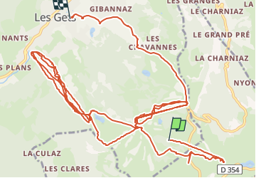

Length
25 km

Max alt
1807 m

Uphill gradient
2141 m
Km-Effort
55 km

Min alt
1112 m

Downhill gradient
2480 m
Boucle
No
Creation date :
2014-12-10 00:00:00.0
Updated on :
2014-12-10 00:00:00.0
2h59
Difficulty : Unknown

FREE GPS app for hiking
 SityTrail
IGN / Geographical institutes
SityTrail Plus
The world is yours!
About
Trail Other activity of 25 km to be discovered at Auvergne-Rhône-Alpes, Upper Savoy, Les Gets. This trail is proposed by ROBERT-MICHEL.
Positioning
Country:
France
Region :
Auvergne-Rhône-Alpes
Department/Province :
Upper Savoy
Municipality :
Les Gets
Location:
Unknown
Start:(Dec)
Start:(UTM)
321639 ; 5111576 (32T) N.
Comments